
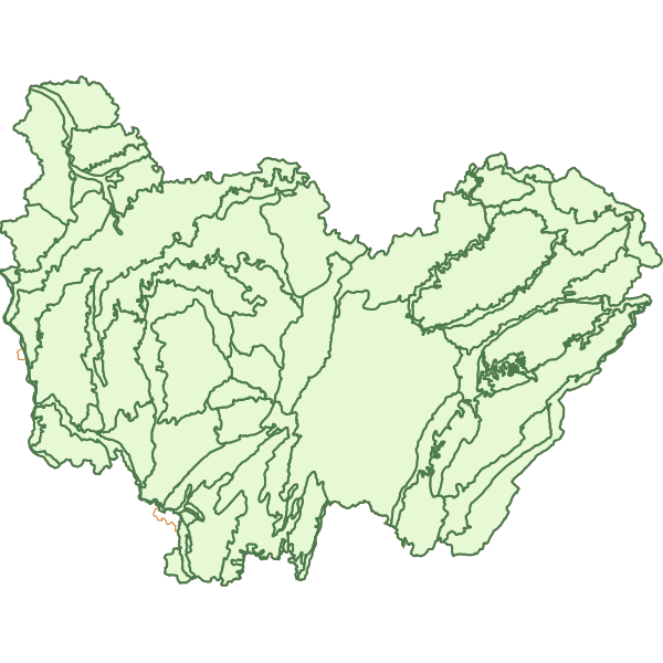
Régions naturelles en Bourgogne-Franche-Comté
Il s'agit d'une cartographie des régions naturelles harmonisées au niveau BFC créée pour la numérotation des Zones d'Intérêt Ecologique, Faunistique et Floristique, permettant ainsi une localisation plus facile des zones.Pour la partie Bourguignonne de la région, elle permet aussi la codification des études naturalistes connues par la DREAL (département biodiversité). Elle a été validée par le groupe de travail ZNIEFF du Conseil Scientifique Régional du Patrimoine Naturel de Bourgogne-Franche-Comté en octobre 2017.
|
|
Citation proposal
(2018) . Régions naturelles en Bourgogne-Franche-Comté. https://inspire.ternum-bfc.fr/geonetwork/srv/api/records/86727ade-13f2-423d-bfda-304d1fe9a693 |
Simple
- Date ( Revision )
- 2021-02-02
- Date ( Publication )
- 2018-01-02
- Date ( Creation )
- 2020-03-05
Identifier
No information provided.
Identifier
No information provided.
Owner
- Contact instructions
- logo
- Maintenance and update frequency
- notPlanned Not planned
- Keywords ( Theme )
-
- Inventaire Nature Biodiversité
- Keywords ( Theme )
-
- Biodiversité
- Keywords
-
- Nature
- Keywords ( Theme )
-
- Paysage
- Keywords ( Theme )
-
- Milieu physique
- Use limitation
- Access constraints
- otherRestrictions Other restrictions
- Access constraints
- otherRestrictions Other restrictions
- Access constraints
- otherRestrictions Other restrictions
- Use constraints
- otherRestrictions Other restrictions
- Other constraints
- Pas de restriction d'accès public selon INSPIRE
- Classification
- unclassified Unclassified
- Spatial representation type
- vector Vector
- Denominator
- 25000
- Metadata language
- fre French
- Character set
- utf8 UTF8
- Topic category
-
- Structure
- Environment
- Description
- Bourgogne-Franche-Comté
N
S
E
W
))
- Reference system identifier
- EPSG / 2154
- Distribution format
-
- shapefile (1 )
- OnLine resource
-
https://trouver.ternum-bfc.fr/dataset/regions-naturelles-en-bourgogne-franche-comte/resource/43114d3c-d526-425b-91be-5a5e1988ecfb
n_region_naturelle_s_r27.zip
- Hierarchy level
- dataset Dataset
- Statement
- Cartographie réalisée à partir de la carte des ensembles naturels de Bourgogne datant de 2012, elle aussi réalisée dans le cadre de la modernisation de l'inventaire ZNIEFF et de la carte des régions naturelles de Franche-Comté datant de 2011, réalisée quant à elle pour codifier les études naturalistes de la région.Cette dernière carte a été notablement simplifiée.
- Date
gmd:MD_Metadata
- File identifier
- 86727ade-13f2-423d-bfda-304d1fe9a693 XML
- Metadata language
- fre French
- Character set
- utf8 UTF8
- Hierarchy level
- dataset Dataset
- Date stamp
- 2021-09-08
- Metadata standard name
- ISO 19115/19139
- Metadata standard version
- Cor 1:2006
Author
- Contact instructions
- logo
Point of contact
- Contact instructions
- logo
Distributor
- Contact instructions
- logo
Overviews
Provided by

Views
86727ade-13f2-423d-bfda-304d1fe9a693
Access to the portal
Read here the full details and access to the data.
Associated resources
Not available