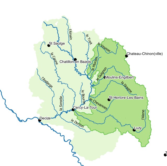
Périmètres du contrat territorial Aron Morvan dans le Parc naturel régional du Morvan
Le contrat territorial est un outil de l’Agence de l’eau Loire-Bretagne et de ses partenaires pour intervenir sur les rivières. Le contrat territorial Aron préparé entre le Parc naturel régional du Morvan et l’Agence de l’eau Loire-Bretagne a été signé le 4 juillet 2017, pour une durée de 5 ans. Il associe le Conseil régional, les collectivités du territoire, les Fédérations de pêche, la Société d’histoire naturelle d’Autun et le Conservatoire botanique. Les signataires du contrat ont pour objectif de restaurer et maintenir la qualité des rivières et des milieux aquatiques du territoire, qui concerne 30 communes réparties sur 6 bassins versants: le Veynon, le Guignon, le Morion, la Dragne, le Chevannes et l'Alène
|
|
Citation proposal
(2020) . Périmètres du contrat territorial Aron Morvan dans le Parc naturel régional du Morvan. https://inspire.ternum-bfc.fr/geonetwork/srv/api/records/171074e3-ae22-4812-b717-1beea992d322 |
- Identification
- Distribution
- Quality
- Spatial rep.
- Ref. system
- Content
- Portrayal
- Metadata
- Md. constraints
- Md. maintenance
- Schema info
Identification
Data identification
Citation
- Date ( Revision )
- 2020-11-20
- Date ( Publication )
- 2020-10-13
- Date ( Creation )
- 2020-10-13
Identifier
No information provided.
Identifier
No information provided.
Owner
- Contact instructions
- logo
- Maintenance and update frequency
- As needed
- Keywords ( Theme )
-
- contrat territorial
- Keywords ( Theme )
-
- CT Aron
- Keywords
-
- Parc Naturel Régional
- Keywords
-
- périmètre
- Keywords
-
- PNR du Morvan
- Keywords
-
- qualité des rivières
- Keywords
-
- restauration écologique
- GEMET - INSPIRE themes, version 1.0 ( Theme )
-
- Administrative units
- Use limitation
Legal constraints
- Use limitation
- PNR Morvan
- Access constraints
- Other restrictions
- Access constraints
- Other restrictions
- Use constraints
- Other restrictions
- Other constraints
- Pas de restriction d'accès public selon INSPIRE
- Classification
- Unclassified
- Spatial representation type
- Vector
- Metadata language
- French
- Character set
- UTF8
- Topic category
-
- Environment
- Boundaries
Distribution
Distribution
- Distribution format
-
- ()
Digital transfer options
- OnLine resource
-
BV_Aron_Topo_BDTOPAGE_S_BLB.geojson
BV_Aron_Topo_BDTOPAGE_S_BLB.geojson
- OnLine resource
-
CT_Aron_S_BLB.geojson
CT_Aron_S_BLB.geojson
- OnLine resource
-
Sous_BV_Aron_Topo_BDTOPAGE_S_BLB.geojson
Sous_BV_Aron_Topo_BDTOPAGE_S_BLB.geojson
- OnLine resource
-
Communes_Adherentes_CT_Aron_ADMINEXPRESS_S_R27.geojson
Communes_Adherentes_CT_Aron_ADMINEXPRESS_S_R27.geojson
- OnLine resource
-
CE_Arron_Allfuents_Principaux_L_BLB.geojson
CE_Arron_Allfuents_Principaux_L_BLB.geojson
OnLine resource
No information provided.
Quality
Data quality
- Hierarchy level
- Dataset
Ref. system
- Reference system identifier
- EPSG / 2154
Metadata
Metadata
- File identifier
- 171074e3-ae22-4812-b717-1beea992d322 XML
- Metadata language
- French
- Character set
- UTF8
- Hierarchy level
- Dataset
- Date stamp
- 2021-02-26
- Metadata standard name
- ISO 19115/19139
- Metadata standard version
- Cor 1:2006
Author
- Contact instructions
- logo
Overviews

Provided by

Views
171074e3-ae22-4812-b717-1beea992d322
Access to the portal
Read here the full details and access to the data.
Associated resources
Not available
